Volcanic Monitoring
Simultaneous Gravity and GPS measurements have been proven a powerful combination for detecting subsurface mass or density changes long before eruption precursors appear. High precision continuous gravity measurements are paramount for detecting fast changes in density and phase, as well as magma movements and separating seasonal effects from deeper processes that may occur over years. Nonetheless, the standard spring gravity meters used for these measurements are limited to 10 to 15 Gal precision and are degraded by non-linear drifts, scale factor variability and environmental effects. These problems interfere with modeling volcanic structural changes taking place over years to decades.
Benefits of iGRAV®
- Continuous Gravity Data
- Sub-μGal Precision
- Ultra-low Linear Drift
- Extremely Low Noise
- Constant Scale Factor
- Insensitive to Local Environment
- Tilt Correction
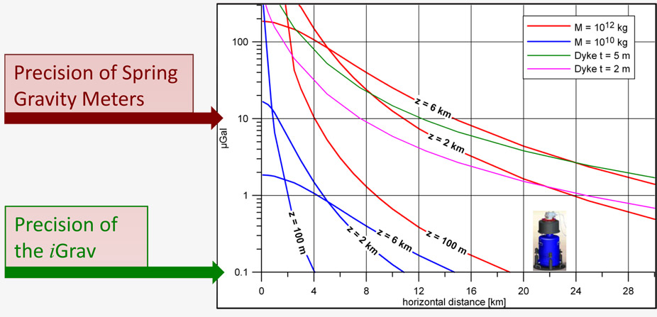
High sensitivity, allows measuring typical volcanic processesas far as 30 km away from the edifice:
- Safe distance
- Discriminating between shallow and deeper processes
GWR Instruments, Inc. is introducing the iGrav Superconducting Gravity Meter as an ideal choice for continuous volcano monitoring. The iGrav will improve precision to sub-μGal levels and will eliminate drifts and scale factor variability. The iGrav will provide a high precision, continuous gravity record that is ideal for interpreting volcanic activity and correlating with other geophysical measurements.
Detection of Mass Redistribution Long Before Eruption Precursors Appear
- Magma Movements on Different Time Scales:
- Intrusive mechanism leading to eruption
- Magma drainage out of a reservoir, magma migration from central conduit to fractures
- Magma storage
- Accumulation of magma at depth, increasing pressurization in the volcanic conduit and potential for explosive eruption
- Gas release
- Vesiculation (density decrease) and crystallization (density increase)
- Monitoring mass changes without significant vertical deformation (e.g. increase in CO2increases magma compressibility (Bonvalot et al., 2008))
- The iGrav is an indispensible forecasting tool for monitoring aseismic mass changes (e.g. CampiFlegreior PhlegraeanFields, Naples)
- Volcano-groundwater Interactions:
- Discriminating between the intrusion of magma, water and gas
- Groundwater dynamics within a volcanic edifice (potential for slope failure, lahar generation and phreatic eruptions)
- Hydrothermal systems (e.g. Long Valley and Yellowstone calderas, Mt Uzu, Mt Sakurajima)
- Continuous Gravity Monitoring Enables:
- Avoiding aliasing from intermittent 4D gravity campaigns
- Recovering functioning laws and therefore, discriminating clearly between models for sources of volcano unrest
- Investigating short period (e.g. bubble formation and collapse in Strombolian activity) gravity changes
- Development of an accurate surface hydrological model to achieve μGal precision
- Precise modeling of Earth and ocean tides and atmospheric signals
- Changes in the mechanical response of the edifice to the tidal forces
- Providing a precise reference point to anchor microgravity surveys
- Integration and Correlation with Other Techniques:
- Combining with GPS - Most powerful combination to separate and interpret change in gravity with expansion, deflation or stability of volcanoes’ surface
- Combining with Absolute Gravity extends spectrum of results to years and decades for studying long term reservoir activity
- Correlation with seismic activity and long period seismic signals
Network of iGrav®
- Allow Monitoring at Safe Distance
- Enable Discriminating Between Shallow and Deep Processes
- Horizontal Gradients Probe Mass / Density Variations at Depth Over Both Space and Time
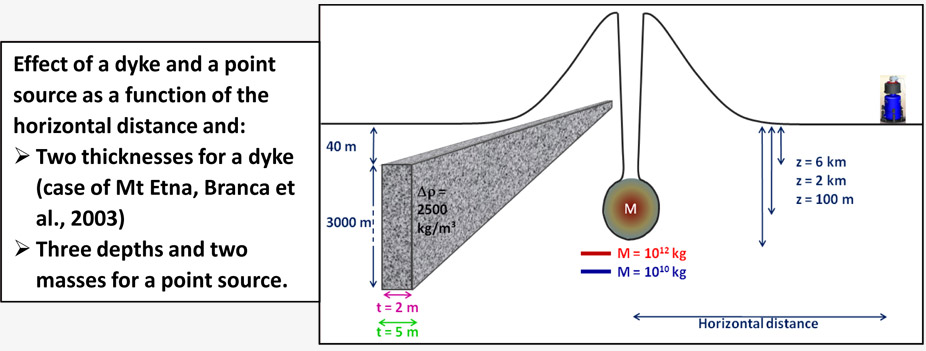
- Two iGrav® at distances of 1 and 10 km may allow discriminating between point sources from dyke intrusion or between shallow and deeper processes
- One iGrav can measure the influence of a 2 x 3000 m dyke or of a 1012 kg point source at a distance of 30 km
- A Few Strategically Positioned iGrav® will Dramatically Reduce Aliasing of Time-lapse Microgravity Surveys
Models of Volcanic Sources
As the models below show - Volcanic gravity changes range in amplitude from a few Gal to several hundred Gal depending on the size and depth of the source. Changes may occur suddenly in a few seconds or slowly over days, months or years. SGs have proven their precision and stability in distinguishing hydrological models with signal amplitudes of a few tens of Gal over a similar range of periods. The iGrav is a proven choice to monitor and separate these complex volcanic signal sources.


iGrav™ Superconducting Gravity Meter
- Sampling Rate: 1 Hz
- Drift: Linear and < 5 µGal / Year
- Precision: 0.2 µGal/Hz1/2 ⇔ 0.02 µGal @ 100 s
- Calibration: Stable to a Part in 104 for Decades!
download
![]() Volcanic Monitoring (PDF - 0.98MB)
Volcanic Monitoring (PDF - 0.98MB)


 Print This Page

